“Home chain Radar”. What’s that all about? Well, before World War 2 started, the government set out to provide an early warning system which would be able to detect nasty airborne fighters before they hit the shores of Blighty.
The project to sort this out fell in the lap of Sir Robert Watson-Watt, clever bloke, who was the technical head to the British Air Ministry. He came up with a plan which was to be the first fully “linked” radar station network. This was to, in effect, put a chain of radar stations all around the coast line of the UK. Starting along the South East, the stations looked toward France where the airborne advance was likely to come from.
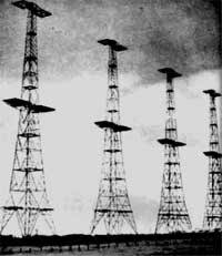
By today’s standards, the technology was very basic. In fact by, 1930-1940s standards, the Home Chain radar was thought to be outdated. But Watson-Watt stood his ground. Churchill wanted something now. The technology was to build 350 foot tall masts with aerial arrays slung between them. These would be fed by powerful HF radio transmitters using the 12 mtrs, 25 megacycle frequency range. These arrays transmitted a signal out across the channel. A few hundred yards away would be another mast and aerial setup which received any small signal reflected by potential evil aircraft. Yes, the systems were basic, but the manufacture of the equipment would be easily taken on by domestic radio companies such as ECKO, HMV and EMI, as well as Cossor, who’s labour force was now diverted to the war effort.
The receiving huts were manned, or womaned, normally, by WAAFs, Women’s Auxiliary Air Force. These nice ladies, dressed in khaki uniforms, stockings…sorry I must stop there, would huddle around a small TV like screen, about 6” diameter. The image comprised of a splodge at the bottom, which indicated the stations land position. The rest of the screen had lines, marking distance in miles away. The reflected signal from an aircraft was seen on the screen as another ill defined mass, X number of miles away. Of course this could have been a massive flock of birds or heavy cloud. But a trained WAAF could distinguish what was what. This information was collated and telephoned through to RAF Fighter Command at Bently Priory. No email in those days. There, the “Map Plotters” would determine the plan of attack and send commands to scramble. The information also went to the Navy and the Barrage Balloon controllers.
The system did have limitations. The radar didn’t have spinning dishes like you see on boats. It was fixed and could only “see” with about a 60 degree view. That’s why many stations were chained together, to give a contiguous view along the cost. It also wasn’t much good at detecting low level aircraft. The system known as AMES1 (Air Ministry Experimental Station) was upgraded throughout the war. AMES2, 13… was developed using higher frequency systems which increased accuracy and could see aircraft coming in low level, hugging the sea.
By 1943-44, a new generation of radar was being deployed, an example being Ground Control Intercept radar. This used Microwave frequencies, 1.3 gigahertz. The power being generated by a Magnetron, similar to the device used in your microwave oven. The images and detail were far better than the early systems. Airborne radar was also being used following developments by the likes of top engineers such as Alan Blumleine.
So there we have it. A system what was very crude and ridiculed at the time by many, but worked and did what it said on the tin. That phrase would not have been understood in 1940! So please say thanks to Sir Robert Watson-Watt when you get a minute.